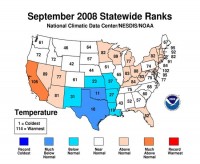
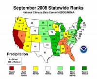
September 2008 was the 49th warmest and 38th wettest on record for the contiguous United States, according to an analysis by NOAA’s National Climatic Data Center in Asheville, N.C., based on records dating back to 1895.
California had its 10th warmest September, while Texas had its 10th coolest September on record. The southern United States experienced its 11th coolest September on record, with an average temperature of 71.7 degrees F, 2.6 degrees below the 20th century mean.

See larger image here
Based on NOAA’s Residential Energy Demand Temperature Index, the contiguous U.S. temperature-related energy demand (primarily cooling degree days) was 1.7 percent below average in September.
The United States measured below-average precipitation in areas west of the Rockies, and from Florida to Kentucky. However, the remnants of hurricanes Gustav, Hanna and Ike brought above average precipitation from Louisiana to Michigan and throughout the Northeast.
California had its driest September on record, with an average of just 0.01 inch of precipitation - 0.45 inches below the 20th century average. Kentucky, Florida, Georgia, Nevada and Tennessee had one of their driest Septembers on record.
Arkansas, Connecticut, Illinois, Louisiana, Maine, Massachusetts, Michigan, Missouri, New Hampshire, and Rhode Island experienced one of their 10 wettest Septembers on record.

See larger image here
Gustav, Hanna and Ike made landfall in the United States in September. Gustav struck as a Category 2 storm near Cocodrie, La. on September 1. Hanna came ashore near Myrtle Beach, S.C. as a tropical storm on September 6 and moved northeast along the Atlantic coast. Hurricane Ike made landfall at Galveston, Texas on September 13 as a Category 2 storm.
Wildfire activity was well below average across the United States in September. See full release here.


