


Note the following is an addendum to the tornado alarmist claim rebuttals relative to the May tornado streak. The image at the top of the page can take you to the full updated alarmist claim rebuttal site with the latest updates as each season passes.
Joseph D’Aleo, CCM, AMS Fellow
Just like the hurricane impact spikes in 2017 and 2018 after a record almost 12-year period without a landfalling major hurricane, tornadoes have bounced back big-time after 7 quiet years ending in 2018, the quietest in the entire record. But we will show you it was not global warming but actually a pattern with extreme persistent central and southwestern cold and precipitation that led to the tornado rebound and also the flooding that accompanied it.
This has been a cold winter and spring in much of the nation (except the southeast) and that has lingered through the entire spring.
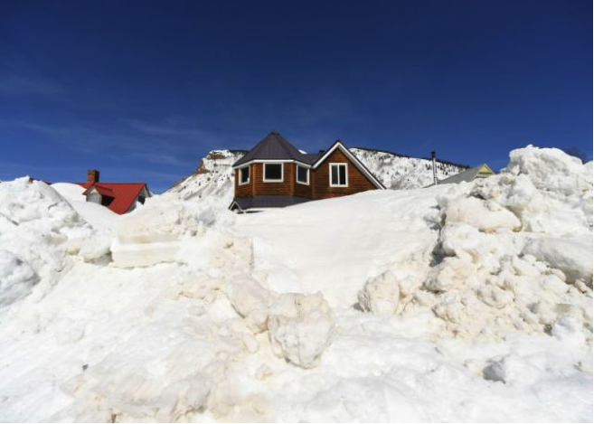
In the cold air, snowpack has persisted in the west. Water and snowpack in the mountains of California ran 30% above normal for the Water Year (since October 1). This is true into the Rockies. The Denver Post on May 22 reported:
One year has made a massive difference in boosting Colorado’s snowpack.
Statewide snowpack was at a remarkable 202 percent of its season-to-date average as of Tuesday, according to official data from the National Resources Conservation Service (NRCS) website. This year’s snowpack is approximately five times larger than it was a year ago at this time. An NRCS estimate placed this year’s Colorado snowpack at 519 percent of May 21, 2018 levels.
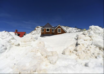
Some parts of the state are running at more than three times their typical snow levels for the third week of May. In the San Juan Mountains, snowpack was at 302 percent of its season-to-date average. Here is a May 28 image from Silverton, Colorado.
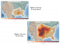
That deep and very cold for May western trough helped pump up a warm southeast ridge the last few weeks.
Enlarged
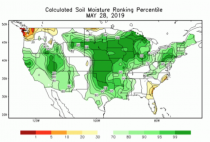
During the winter and spring the pattern was very wet for most of the nation but especially the central. The soil moisture is at the highest levels - above the 99% percentile in parts of the central and the areas of drought is at the lowest level of the record.
_thumb_thumb.png)
The late winter and spring rains, snowmelt and runoff from over frozen ground led to waves of extreme, in places record flooding.
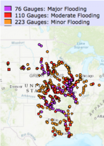
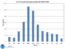
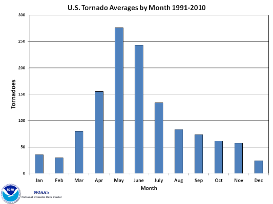
When heat energy built in the ridge in Mid-May, the thunderstorms bringing heavy rains in the disturbances became increasingly severe, a phenomenon meteorologists call the ring-of-fire. 13 straight days of tornado outbreaks increased the tornado totals to well over 400 in May. The final tally will take months to reconcile as they remove duplication (often15%). May is the climatological peak but June is a close second.
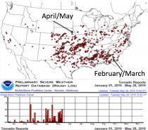
The early season was active, mainly in the Gulf, fitting climatology. Since April, action has moved to the central and points east.
In 2011, the last active tornado season, we had very extreme severe weather in the spring. It quieted in June.
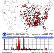
We currently trail 2008 and 2011 year to date.
_thumb.png)
.png)
.png)
Claims that the increased storms are the result of climate change/global warming are not supported by the data.
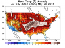
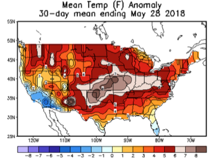
2018 was the quietest tornado season - with 170 tornados in May compared to 442 to date this year. 2018 had a very warm May. Storms require contrast of warm and cold. We had very strong contrast this spring providing the ideal environment for heavy flooding and frequent strong tornados.
Enlarged
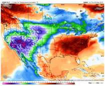
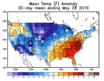
Major storms that produce heavy rains and outbreaks of severe weather occur with a rich moisture environment and strong jet streams that result from a significant contrast of warm and cold. In 2019, the U.S. faced high moisture levels and, as shown below, a very large temperature differential this spring providing the ideal environment for heavy flooding and frequent and strong tornados.
Enlarged
Major storms that produce heavy rains and outbreaks of severe weather occur with a rich moisture environment and strong jet streams that result from a significant contrast of warm and cold. In 2019, the U.S. faced high moisture levels and, as shown below, a very large temperature differential this spring providing the ideal environment for heavy flooding and frequent and strong tornados.
The most commonly used measure of the Pacific Basin temperatures is the Pacific Decadal Oscillation or PDO. When the eastern Pacific is cold, the PDO is negative.
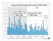
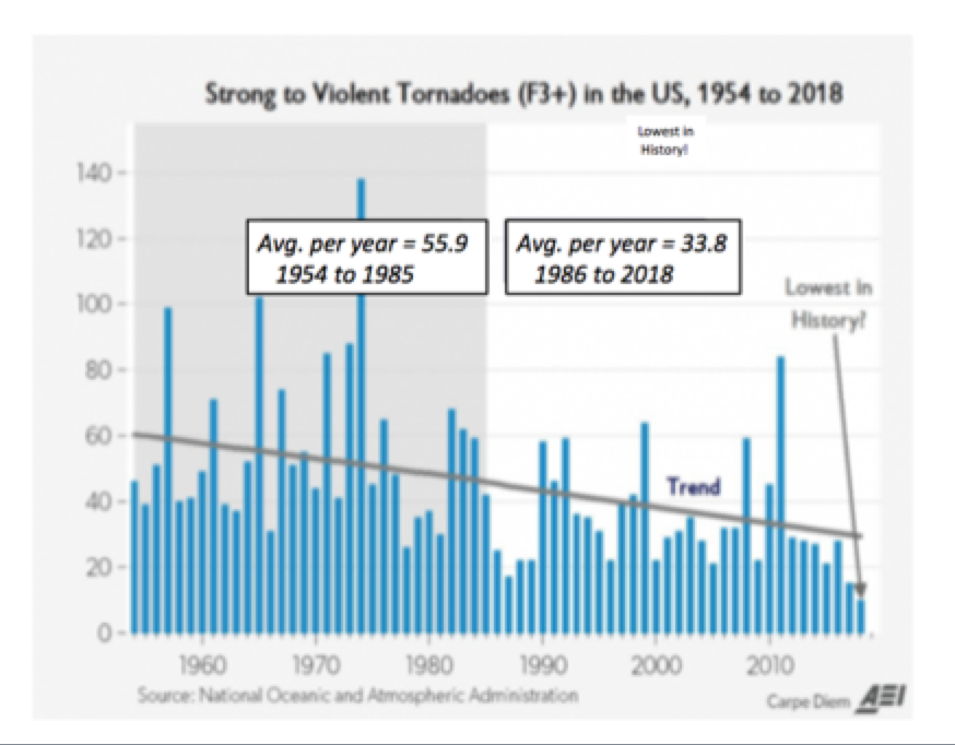
The chart below depicts in orange columns, the number of strong EF3+ tornadoes per year since 1954. The annual PDO is the blue dashed lines. As shown in the figure, tornados are more frequent and likely to be stronger when the eastern Pacific is cold as it was from the 1950s to mid-1970s, as well as around 1999 and 2008 and 2011. This is because, as occurred this year, a cold eastern Pacific favors cold winters and springs in the west and central U.S. as well as warmer southeastern states.
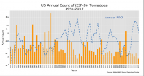
The official, final value for the number of EF3+ storms in 2018 has not yet been released, but the number of EF3+ storms reported unofficially was less than half that of 2017, a new low.
Notice how cold eras and years tend to correspond with increased tornadic activity. This year, the PDO has behaved as it did in 1999, 2008 and 2011 when there were spikes in tornadic activity as noted above. Over at least the past century, the PDO has had a multi decadal cycle, and the warm phase is now over 40 years old. Thus, totally unrelated to CO2 emissions, a return of the cold PDO mode resulting in more tornadoes on an annual average basis is certainly now possible.