


By Joseph D’Aleo, CCM
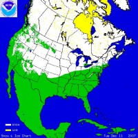
A persistent strong boundary between cold air across Canada and the northern tier states and mild air to the south and southeast has produced a series of ice and snow events that have left nearly a million in the dark across at least 7 states. You can see the large area covered by snow and ice Tuesday morning.
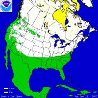
Over the next week, two more systems will bring more precipitation in this area and in the end expand the area of snowcover to the south. Colder air will build in behind the latest system, the warmest of the series and then be reinforced later this week with a moderate precipitation event, this one mainly frozen with areas including Cleveland, Pittsburgh, Philadelphia, New York City and perhaps Boston and Providence. The third system this weekend could become quite a major snowstorm for many areas depositing a foot or more of the white stuff. It is a little early to determine exact track and where the heaviest snow will fall but places from the nation’s capitol to New York City and Boston could be included although the chances will be greatest inland as is often the case with December storms. Very cold air will follow in the storm’s wake into the east well into next week. The snowcover by Monday could look like.
A warm-up may try and follow starting in the central later next week but warm–ups after a good snowpack develops in December with feeble sunshine often disappoint. La Ninas are noted for their variability month-to-month when weak and developing southeast warmth when strong. Read why that MIGHT not happen this winter here.