


By Joseph D’Aleo, Weatherbell Analytics
A persistent Pacific jet stream has pounded Alaska but kept winter at bay in the early winter in the lower 48 states.
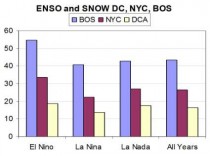
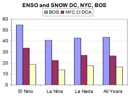
In the Washington Post, they reported on this lack of snow drought so far this season and admitted it was typical of La Ninas. All the cities of the east do well in El Nino winters, with major snowstorms.
Enlarged
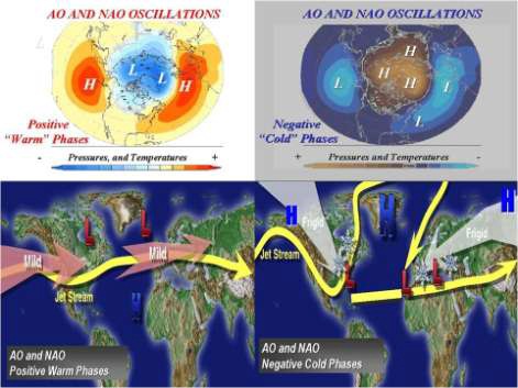
This year winter started with a strong polar vortex. This strengthens the westerlies and pumps Pacific Maritime air in to North America and mild Atlantic air into Europe. In 2009/10 in contrast, a very weak polar vortex allowed warmer air can penetrate into the polar high atmosphere and buckle the jet stream in ways that allows cold air to dump to middle latitudes. Big snows resulted.
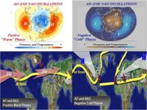
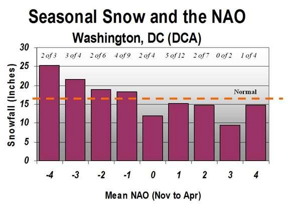
A negative NAO (and AO) leads to heavy snow in the major cities including DC.

Enlarged
2009/10 had record blocking negative NAO and an El Nino. The combination produced all-time record snows.

This season we have a La Nina and started the season with a very positive NAO and AO. That is why snow has been so hard to come by. The NAO and AO are turning negative. This will help but especially in the northeast.
TRENDS DOWN?
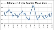
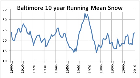
In the Post, Jason Sabenow reported that the DC airports have seen a decline in snowfall of about an inch a decade. Doing a 10 year running mean of seasonal snowfall does not confirm this claim. Baltimore showed a big spike in the 1960s, a cold decade with very negative AO/NAO and 4 cold El Ninos. It declined in the La Ninas of the 1970s but then has increased slightly the last 35 years.
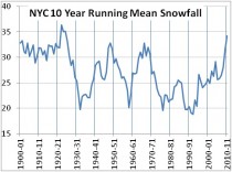
New York City running means show ups and downs but current values are the largest since the 1910s and 1920s. Spikes also were seen in the 1940s and 1960s.
Enlarged
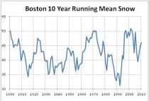
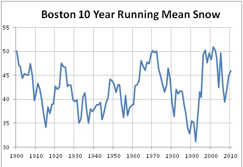
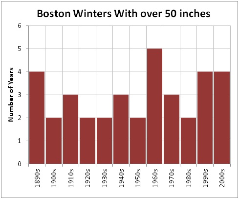
For Boston, the 1960s and 1990s/2000s were the peak snow years.
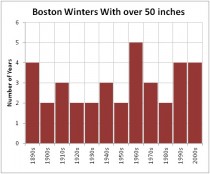
That is seen also in the number of years with over 50 inches of snow.
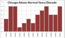
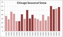
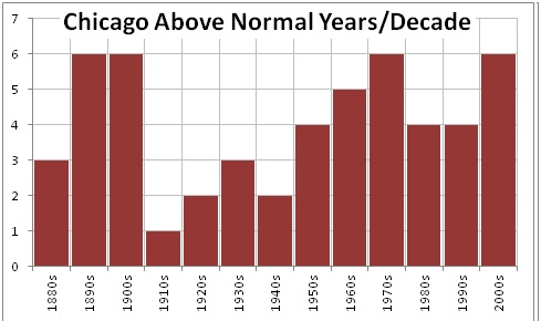
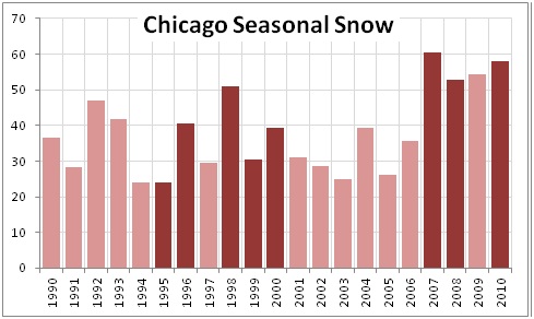
Chicago has had more recent above normal snow years like it did in the last cold PDO years (with more La Ninas) from the 1950s to 1970s.
Enlarged
Chicago snowfall is running below normal and after four big years, that would not be surprising even with La Nina.
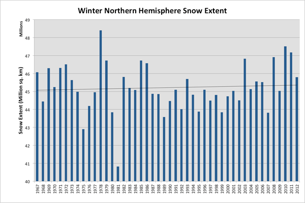
As for northern hemisphere snow in winter, it has trended up since 1967. Behind 1977/78 we find 2009/10, 2010/22, 2007/08 and 2002/03.
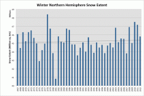
This is likely to fall far short of the top 5 this year, but the trends in the big cities and hemisphere are up not down. AND the winter will turn more active given the redevelopment of blocking. Most of the traditional La Nina snowy areas will do better starting the rest of this month. Last winter most of the action came early ending in early February. This year will be the opposite. DC will likely have to wait for the next El Nino (2012/13?) to cash in. But then again AGWers have it covered either way.
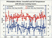
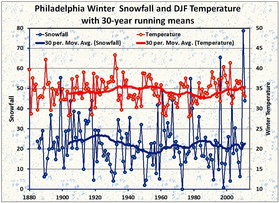
BTW, Dr. Richard Keen sent this note about PHL.
The PHL data (attached) is an updated version of the one I posted in an ICECAP article a year ago, and tells the same story as all the other locations. There is little trend in either snowfall or winter temperature over the past 130 years, and recent averages are the same as those 60 or 80 years ago. There is a bit of an up-and-down signal in both snowfall and temperature, all following the AMO quite nicely.
Anecdotally, Philadelphia’s snow low point in the 1930’s - 1950’s was due to a warm AMO that brought several exceptional hurricanes (culminating in 1954’s Hazel), mild winters, hot summers, and so little snow that I couldn’t use a Flexible Flyer sled I got for Christmas until three winters had passed. So a light winter with little snow is nothing new.
He adds from his mountain home in CO, Not a dud winter here - second snowiest December (71.6 inches) and season-to-date as of 12/31 (115.6), and a record wind gust (110 mph) on New Year’s eve. Ground blizzards and 70+ gusts most days this month.
I’m glad I installed a supplemental propane stove in the living room last summer. Thank God for having the foresight to load us up with fossil fuels a billion years ago.