


By Joe D’Aleo, CCM
A big surge of snow in many parts of the Northern Hemisphere in the last half of January resulted in January being the snowiest for the hemisphere since satellite records began in 1966.
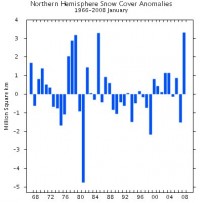
See full size image here
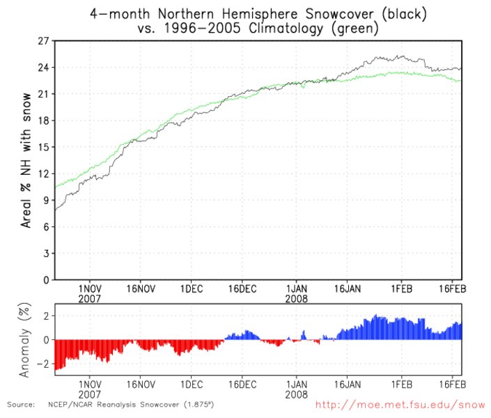
After some retreat, a second surge took place this month and again now, the snowcover is well above the normal for the month. Data comes courtesy of Dr. Bob Hart, FSU.
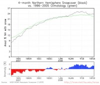
See full size image here
This may result in February again being among the snowiest for the hemisphere for the period of record. It will be a few weeks before that analysis is provided. Extensive snowcover in mid to late winter, something lacking in most recent years often means colder and snowier than normal temperatures for late winter and a delayed spring. Look for more snow events and late potentially damaging cold in the news in the days, weeks and months ahead. This mirrors the happenings in the Southern Hemisphere their last winter and spring. Our South American friends at the METSUL had predicted this outcome for us.
See this story today from North Dakota where long-time cold records were set. Fargo broke a record that had stood for 119 years, with 31 below. The record had been 30 below set in 1889. Madison, Wisconsin where their new record seasonal snowfall has climbed to 86.7 inches (and will climb well above 90 next week on its inexorable trek to 100 inches) set a new record with minus 15F. In Chicago, temperatures are on pace to make it the 4th coldest winter in the last 20 years.