By Joseph D’Aleo, CCM
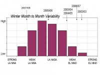
A very stormy few weeks is in the cards as another regime change takes place. La Ninas are notoriously fickle unless they are super strong, We have a moderate La Nina ongoing and a fair amount of variability as I am sure you will agree from a very cold start in early December easing to more seasonable but very snowy conditions. A briefly bitter cold start to January gave way to a record second week warm spell. Frigid air returned in week 3 concentrated in the central states. It has moderated this weekend in the central and will by early week with some rains in the east but another shot of cold will be felt this week mainly across the north.

See full size image here
Intraseasonal variability can relate to episodes of high latitude blocking events (not a factor this year, at least not yet) and to a phenomenon known as the Madden Julian Oscillation; CPC has an excellent FAQ section here that answers questions about this phenomenon. The Australian Bureau of Meteorology tracks this phenomenon closely as it affects the probability and timing of rainfall events there. Tropical forecasters track it for timing enhanced tropical activity in summer and fall. Other forecasters look at it in winter to time stormy periods for the west and central United States and temperature fluctuations elsewhere.
We are entering a phase of the MJO that favors a series of storms for the west and central states that will bring very heavy snows to many areas there (focused mainly on the Midwest in areas like Des Moines, IA, Chicago IL and Madison, WI). You will see stories in the news about these snow events through the next few weeks. These storms will ride up through the northeast but those storm track usually mean rain for the east with the exception maybe in some events for the higher elevations up north and west (northern New York and northern Vermont). With time (in a few weeks) the storm track will shift east and assuming there are bullets left in storm gun, the east would get its shot at more snows, in time for ski areas to recover for the important President’s Day week.


