


By Joseph D’Aleo, CCM, WeatherBell Analytics Co-Chief Meteorologist
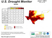
“Based on Palmer Drought Severity Index values, this is the third-worst drought Texas has ever seen in the month of May,” Nielsen-Gammon writes in his blog, the Climate Abyss. “Records go back to 1895. May also marks the end of the driest eight-month period on record.
The worst droughts remain those in 1918 (one of JB and my analogs for last winter) and 1956, according to Texas State Climatologist Nielsen-Gammon. According to the U.S. Drought Monitor, nearly 50 percent of the state remained in what is termed an “exceptional” drought, which means a once in 50-year occurrence. More than 90 percent of the state was experiencing either a severe or exceptional drought. Only parts of north central and northeast Texas were not at least abnormally dry as of May 31.
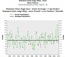
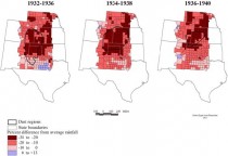
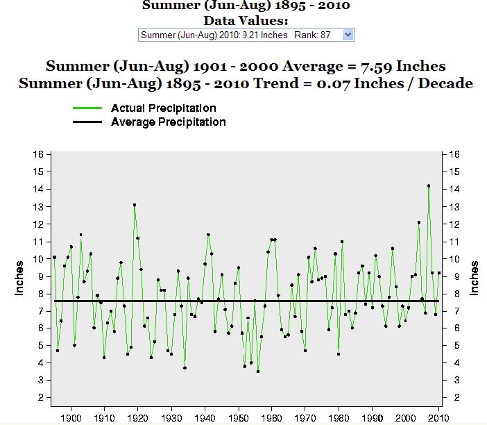
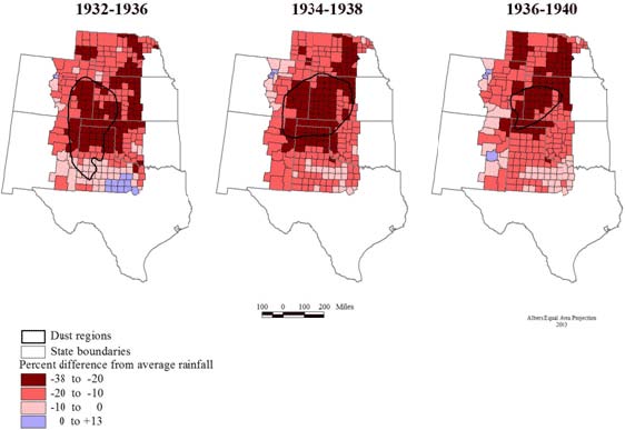
You can see the clustering of drought years for Texas in the 1950s and in the 1930s in the graph that follows. For the United States as a whole the 1930s was the worst decade for drought - The Dust Bowl Years.
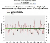
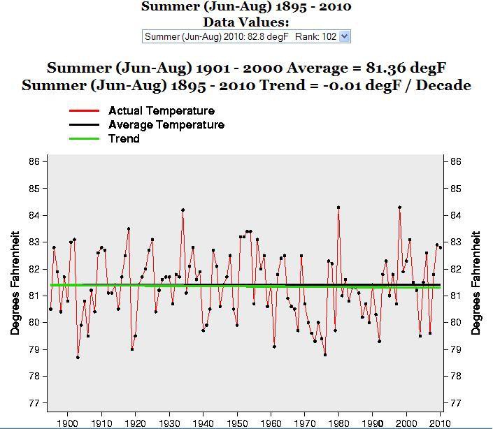
Summer heat the last century peaked in 1934, 1980 and 1998 in Texas with no discernable trend since 1895.
During the 1930s drought, the persistent dryness in the south central built the central heat ridge further and further north eventually setting all time records in many states.
Technically, the driest region of the Plains - southeastern Colorado, southwest Kansas and the panhandles of Oklahoma and Texas - became known as the Dust Bowl, and many dust storms started there. But the entire region, and eventually the entire country, was affected.
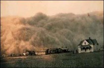
The Dust Bowl got its name after Black Sunday, April 14, 1935. More and more dust storms had been blowing up in the years leading up to that day. In 1932, 14 dust storms were recorded on the Plains. In 1933, there were 38 storms. By 1934, it was estimated that 100 million acres of farmland had lost all or most of the topsoil to the winds. By April 1935, there had been weeks of dust storms, but the cloud that appeared on the horizon that Sunday, the 14th, was the worst. Winds were clocked at 60 mph. Day became night.
The day after Black Sunday, an Associated Press reporter used the term “Dust Bowl” for the first time. In the central and northern plains, dust was everywhere. The dust bowl was caused not just by the dry weather but also by unwise farming practices. Earlier settlers plowed under the natural tall grasses that covered the plains and planted crops they had planted in the wetter East. When the drought came, the crops failed, the ground was uncovered and the incessant winds produced the dust storms.
After the dust bowl, farmers ended over-cropping, over-grazing and improper farm methods. Since then wheat which is tolerant of drier conditions was grown in the semiarid west and other crops further east
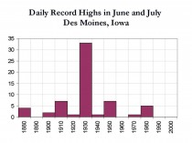
Dry ground enhances heat. Heat can expand north and east (sometimes even west). This can be clearly seen in the plot of record highs for Des Moines, Iowa for June and July. Note 33 of the records were in the 1930s and interestingly none since 1988.
Enlarged.
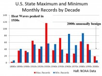
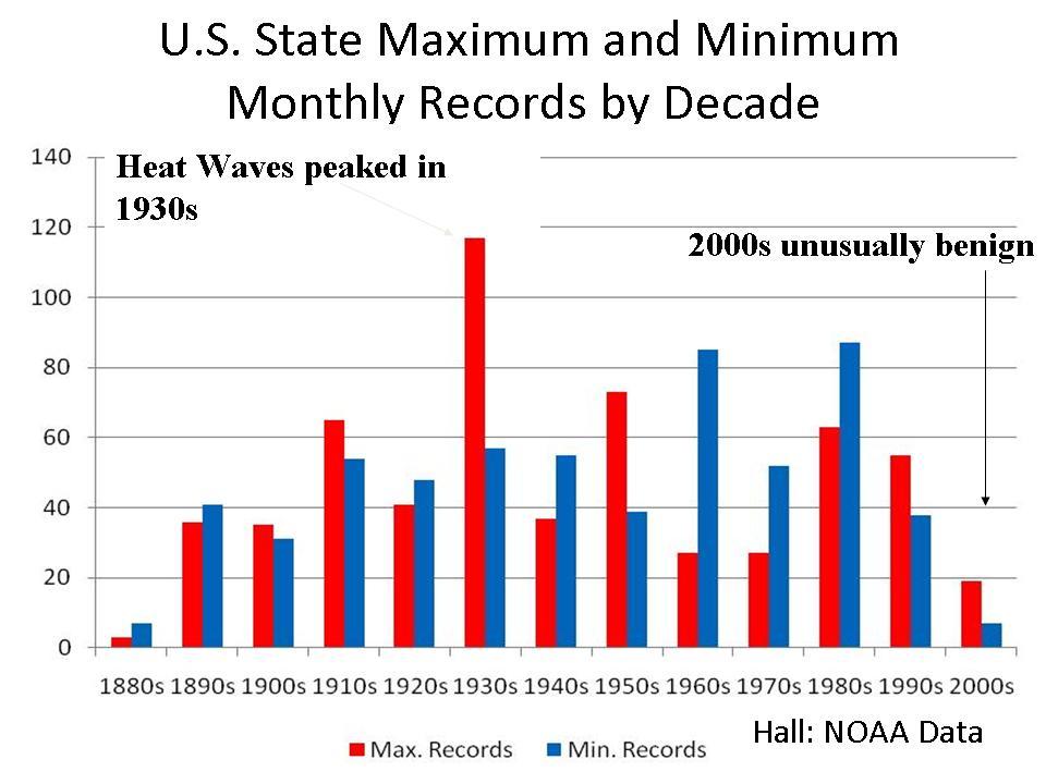
This is true actually for all the states. The 1930s show the most state all-time record highs than any other decade, the 1950s second. The cold records actually peaked in the 1980s and 1960s.
Enlarged.
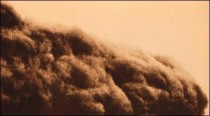
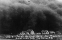
Here is another NOAA image of a dust storm during the 1930s approaching Stratford, TX
Those who have registered on WeatherBell can see the rest of this story with more images and also daily blogs by Joe Bastardi, Co-chief meteorologist and I on Weatherbell.com. We also provide more detailed global analysis and forecasts including long range for global regions for energy and agriculture and retail. Recent blogs have covered the tornadoes, floods and brief heat wave and have explained why the pattern like 2008 and 2009 is in transition to a cooler and wetter one again for the major growing areas while they continue to bake in Texas west to Arizona. We also explained why it would turn wetter and cooler in the UK but dryness should continue to be a problem as we forecast two months ago for France. Watch out for cold and maybe snow again in Argentina the next two weeks with cold reaching into Brazil.
I did stories on the Hurricane of ‘38 and Hurricane Carol and both of us did detailed hurricane season outlooks.
See also a video from FOX BUSINESS with Joe Bastardi on Weatherbell’s home page explaining the wild weather. We had both predicted the floods and tornado outbreaks in the late winter for the spring and the Texas drought last fall. Please join us.