

By Joseph D’Aleo, CCM, AMS Fellow, Weatherbell co-chief Meteorologist
This is August and the east coast season peaks in September with activity in October. August systems often provide just a hint at what is to follow. This year after the winter record cold and snows, spring heavy rains and record flood and tornadoes, a 60 to 100 year drought in Texas and nearby areas. A year without a summer in the Northwest and brutal heat in the south central and at times most other areas of the central and east. Now comes the hurricane season. La Ninas often do far more damage from El Ninos. This was a super La Nina, the second strongest in history (either behind 1917/18 if you use the atmospheric measure, 1955/56 if you use the Multivariate ENSO Index of NOAA CDC Klaus Wolter).
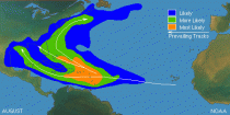
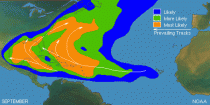
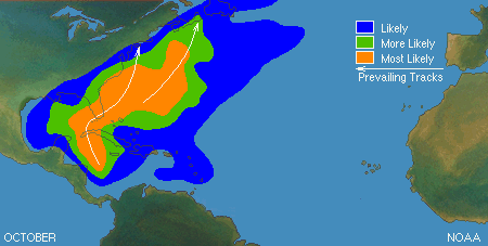
We have already had 5 named storms...nothing significant. But the season really doesn’t kick in most years until mid August. NWS NHC has upgraded their forecast for the hurricane season. Here is the normal hurricane tracks from August to October.

The warm Atlantic and cold Pacific usually mean an east coast landfall. The analogs and model forecasts suggests the trough which has been off the east coast moves inland far enough to threaten trouble for the east coast. These troughs amplify than lift out leaving a weakness a storm in the waters off the east coast can penetrate. The Carolinas and the coast further north including New Jersey and New York are vulnerable. This region is is overdue. This summer was a lot like the 1954 and 1955 summers.
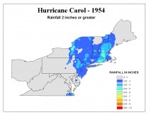
Carol, Edna and Hazel hit in 1954, Connie and Diane in 1955. Even New York City felt the storms effects though not a direct hit.
Historically, some storms have tracked that way.
I wrote on WeatherBell about the Hurricane of ‘38, Hurricane Carol in 1954 and the hurricane season of 1893. And covered the reasons why the northeast east coast and maybe NYC might be threatened this year.
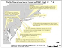
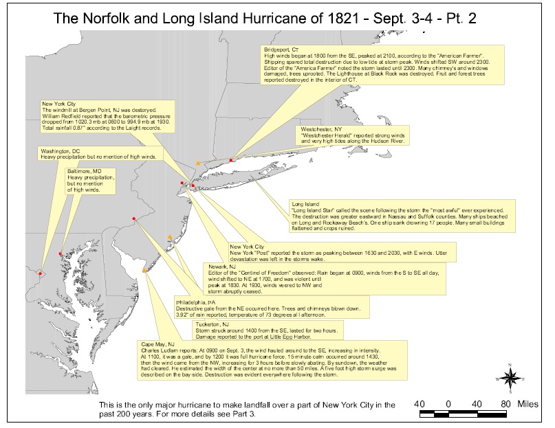
The worst storm recorded for the big apple was the Norfolk and Long Island storm of 1821.
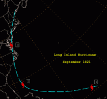
It was estimated to be a category 3 or even 4 when it brushed New Jersey before making landfall on New York CIty 1930 UTC on September 3. This makes it the only major hurricane to directly hit the city since 1800. The late great weather historian David Ludlum summarized it below and enlarged PDF here.
The hurricane produced a storm surge of 13 feet (4 m) in only one hour at Battery Park. Manhattan Island was completely flooded to Canal Street. The flooding would have been much worse, had the hurricane not struck at low tide However, few deaths were reported in the city, since the flooding affected neighborhoods much less populated than today. Strong waves and winds blew many ships ashore along Long Island. One ship sank, killing 17 people.
Please come to WeatherBell and see the daily posts that Joe Bastardi and I provide all through the hurricane and winter seasons ahead. If you have energy, agriculture or retail interests, we provide special services to those markets.