Jan 03, 2008
Highest December Southern Oscillation Index Since 1975
By Eugenio Hackbart, METSUL Weather Center, Brazil
The Australian Bureau of Meteorology released today the December value for the Southern Oscillation Index, one of the most important indicators of the Pacific Ocean conditions. The oscillation is calculated from the monthly or seasonal fluctuations in the air pressure difference between Tahiti and Darwin. Positive values are associated with stronger Pacific trade winds and La Nina episodes. Waters in the central and eastern tropical Pacific Ocean become colder while near Australia they are warmer. The December value released by BoM today for December 2007 was +14.4. This is the highest December SOI value since 1975, an indication of the strength of the ongoing Pacific cold event. It also figures among the top ten positive values for the SOI in December.
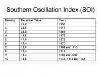
See full size image here.
Read what Eugenio believes that may mean for January and February in the United States here.
Dec 31, 2007
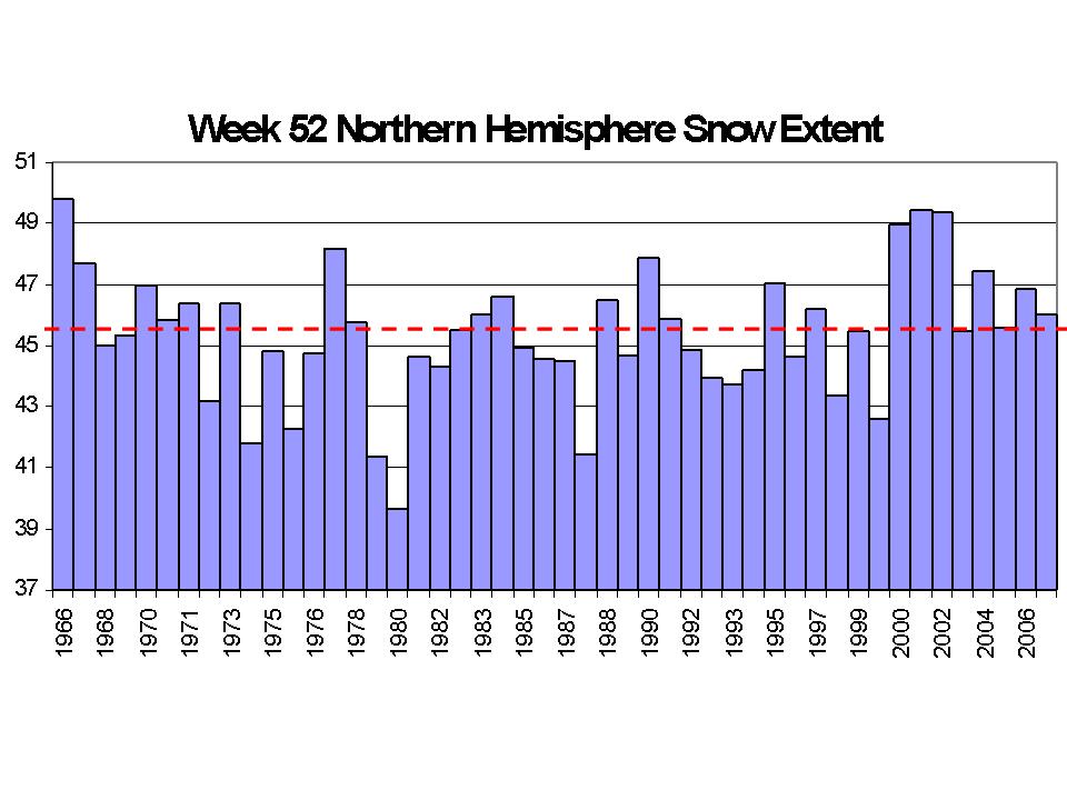
Snowy December Places
By Joseph D’Aleo, CCM
It was a near record or even record snowy December in parts of the central and northeastern United States. Boston received a little under an inch of new snow making this the second snowiest December in the cities snowfall history which extends back to 1890. The total of 27.7 inches fell just 0.2 behind the record of 27.9 set in 1970. Decembers snowfall at Concord, N.H., totaled 44.5 inches, toppling a record of 43 inches that had stood since 1876. Burlington, Vt., got 45.7 inches, far above its 17.2-inch December average, and Portland, Maine, amassed 37.7 inches for its third-snowiest December on record.
In Madison and Milwaukee, Wisconsin too, 2007 was the second snowiest December. For Madison, the total fell just 1.6 inches shy of the record of 35 inches set in 2000. Records in both locations extend back into the 1880s. Just to the south in Rockford, Illinois, it was the 7th snowiest December. The snowiest there too was in 2000.
Kansas was also unusually snowy. Topeka was another second snowiest city with its total of 16.6 inches falling behind only 1983. In Dodge City which has records back to 1871, it ended up the 4th snowiest. 1918 was the snowiest there. In Wichita, Kansas it was the 5th snowiest December.
Notice in the following graph of week 52 snowcover for the northern hemisphere, each year since 2000 has been above the average.
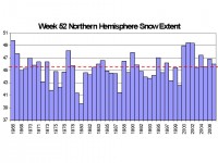
Week 52 of the Year Snowcover extent courtesy of the Rutger’s Snow Lab. See full size image here.
After a frigid start with arctic air across the northern tier dominating, the lack of arctic air late in the month eroded the large deficits that had developed across the north and cental and at months end, the negative anomalies were down to just a few degrees, mainly in the areas where snowfall was heaviest in the plains, western Lakes and northeast. It ended up above normal in the southeast and northern Rockies.
Dec 28, 2007
Weathering and Thermometer Shelters
By Anthony Watts
Patrick Michaels wrote in an American Spectator column today about the surface temperature record and this caught my eye: “Weather equipment is very high-maintenance. The standard temperature shelter is painted white. If the paint wears or discolors, the shelter absorbs more of the sun’s heat and the thermometer inside will read artificially high. But keeping temperature stations well painted probably isn’t the highest priority in a poor country.”
The Stevenson Screen experiment that I had setup this summer is living proof of this. Compare the photo of the whitewash paint screen on 7/13/07 when it was new with one taken today on 12/27/07. No wonder the NWS dumped whitewash as the spec in the 70’s in favor of latex paint. Notice that the Latex painted shelter still looks good today.
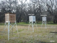
See full size images and more here in the Watts Up With That blog.
Anthony Watts is a former television meteorologist who operates a weather technology and content business. Weather measurement and presentation technology is his specialty. He has led a volunteer effort to document surface observing station siting at surfacestations.org
Dec 22, 2007
Exchange Between Roger Pielke Sr. and Andrew Revkin on Revkin’s Weblog “Climate Consensus Busted?”
By Roger Pielke Sr.
Read in the latest posting, the exchange between Andrew Revkin and Roger Pielke Sr. on the relative importance of the greenhouse gases in climate change.
Roger’s latest reply includes the following comments: However, as I read your reply, you are convinced that the climate will continue to warm from the greenhouse gases. Yet the lack of warming in recent years by several measures (upper ocean heat content, lower tropospheric temperatures), and the at best muted positive feedback from the water vapor feedback, indicates that we know quite a bit less on global warming than you indicate.
I agree the warming could resume (due to the diversity of positive climate forcings of which CO2 is up to 30% in a global average) but the lack of recent agreement between the models and the observations raises questions on whether negative feedbacks and negative climate forcings could actually result in cooling, at least for a period of time. After all the IPCC SPM admits that they left off climate forcings with a low level of scientific understanding.
With respect to added CO2, I am becoming convinced that its effect (threat?) is more from alterations in ocean and land biogeochemistry. rather than its radiative heating. I am also convinced (and have published on this as well) that the more heterogenous climate forcings (due to aerosols and land use/land cover) have a much greater impact on climate through alterations in atmospheric and ocean circulations than do the well-mixed greenhouse gases.
Dec 19, 2007
Year of Global Cooling
By David Deming, Commentary in the Washington Times
Al Gore says global warming is a planetary emergency. It is difficult to see how this can be so when record low temperatures are being set all over the world. In 2007, hundreds of people died, not from global warming, but from cold weather hazards.
Since the mid-19th century, the mean global temperature has increased by 0.7 degrees Celsius. This slight warming is not unusual, and lies well within the range of natural variation. Carbon dioxide continues to build in the atmosphere, but the mean planetary temperature hasn’t increased significantly for nearly nine years. Antarctica is getting colder. Neither the intensity nor the frequency of hurricanes has increased. The 2007 season was the third-quietest since 1966. In 2006 not a single hurricane made landfall in the U.S.
South America this year experienced one of its coldest winters in decades. In Buenos Aires, snow fell for the first time since the year 1918. Dozens of homeless people died from exposure. In Peru, 200 people died from the cold and thousands more became infected with respiratory diseases. Crops failed, livestock perished, and the Peruvian government declared a state of emergency.
Unexpected bitter cold swept the entire Southern Hemisphere in 2007. Johannesburg, South Africa, had the first significant snowfall in 26 years. Australia experienced the coldest June ever. In northeastern Australia, the city of Townsville underwent the longest period of continuously cold weather since 1941. In New Zealand, the weather turned so cold that vineyards were endangered. Read more about 2007 cold here.
David Deming is a geophysicist, an adjunct scholar with the National Center for Policy Analysis, and associate professor of Arts and Sciences at the University of Oklahoma.

