


By Anthony Watts, Watts Up With That
Last summer I attempted to do a survey of Reno’s USHCN official climate station. But I was thwarted by its placement at the Reno International Airport due to security and lack of accessible photographic vantage points. Reno’s USHCN station is particularly important due to it being part of the test cases of stations in the new USHCN2 scheme being implemented by NCDC. It’s also important due to it’s steep temperature trend which appears to be more of an urban heat island (UHI) issue than a climate change issue. It shows up as a hot spot in USHCN contours done by Steve MacIntyre
While there wasn’t good Google Earth photography online last summer, that has since been remedied, and high resolution photographs are now available at Google Earth and at Microsoft’s Live Earth. Having these, I was able to complete the station survey and determine that this station is a CRN4 rating due to proximity to the ILS building with a/c exhaust vents, less than 10 meters away. A CRN4 rating is unusual for an ASOS station.
In wondering about just how this placement between runways on a darker surface environment might contribute to the upward trend in the GISS temperature graph shown above, I did some searching online and soon discovered that NOAA uses Reno’s placement problems as an example in a training manual for climate monitoring COOP managers. They’d already done all the work for me! More on that internal NOAA training manual later, as it has provided a wealth of information previously undisclosed. What is striking about this is that here we have NOAA documenting the effects of an “urban heat bubble” something that Parker 2003 et al say “doesn’t exist”, plus we have inclusion a site with known issues, held up as a bad example for training the operational folks, being used in a case study for the new USHCN2 system. From the manual: “Reno’s busy urban airport has seen the growth of an urban heat bubble on its north end. The corresponding graph of mean annual minimum temperature (average of 365 nighttime minimums each year) has as a consequence been steadily rising.”
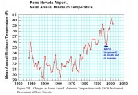
From the NOAA Internal Training Manual
It seems that Parker is looking more and more foolish with his attempts to make UHI “disappear” when NOAA references UHI problems with station placement in their own training manuals. Read more here.
By Joseph D’Aleo, CCM
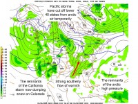
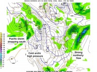
It started with a dump of frigid arctic air last week that brought single digit and sub-zero temperatures across the north and record cold and even flurries to the deep south including Florida. Then a series of storms began to dive out of the trough that has been so persistent near Alaska into California bringing very heavy flooding rains, hurricane force winds and mountain snows measured in yards not feet or inches.
As the cold arctic high moved off the east coast and the western storms came east, southerly winds pumped warm air north shattering records for 138 cities in the plains and midwest Monday and many cities in the east Tuesday. With the warm air came tornadoes as far north as Wisconsin. Tornadoes in the period from the late fall to the late spring are more common in La Nina years. But this warm spell will be short lived as the regime change proceeds. A ridge will gradually replace the trough off the west coast which will shut off the flow of Pacific air into North America and allow the arctic air trapped air up by Alaska and Northern Canada and across the arctic ice to Siberia to spread south into the lower 48 states. Snow will start to rebuild across the north this week with a storm and the east coast may have a nor’easter early next week. Cold air will follow and deepen as the month progresses with some of the coldest air in years possible for much of the nation.
By Joseph D’Aleo, CCM
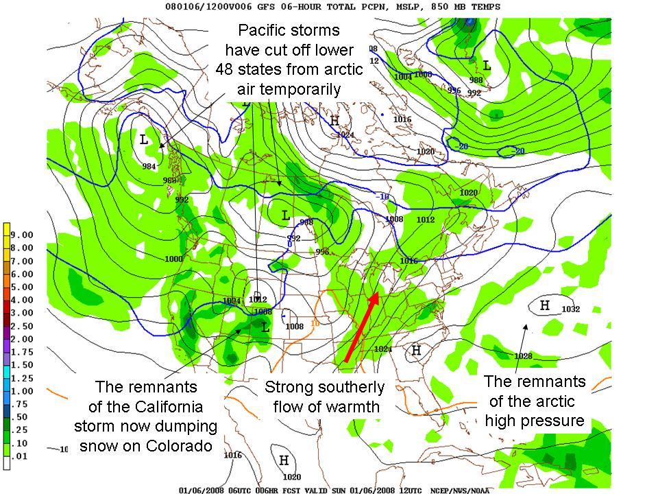
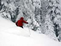
As we have been noting a warm-up (a January Thaw) will help clear ice and snow from driveways of the Midwest and Northeast early this week. This warmth is the result of a return southerly flow behind the big arctic high that brought frigid temperatures to the east and central and even record cold to parts of the deep southeast and ahead of the series of ferocious but now weakening storms coming out of the western states where huge 8-10 foot accumulations of snow and powerful winds and flooding rains were in the news this weekend. Today it is dumping many feet of snow in the Colorado Mountains bringing smiles to skiers and ski areas there.
See full size image here.
Further east, I would not at all be surprised to see some record highs fall. In New York City’s Central Park 60 and even 70 degree temperatures have been reported on most days in January as far back as the 1870s. It could happen this week. No doubt it will allow the Green Network’s Today show alarmists to announce it is another manifestation of global warming. But winter will start returning the middle and latter part of this week and will deepen as the month progresses. They will have some ‘splaining’ to do come the end of week 3 when the frigid winds blow down the big apple canyons again. Of course alarmists have cleverly positioned themselves so that extremes of any kind (warm or cold, wet or dry are all the result of global warming).
The storm track will gradually lift north over the next two weeks as a ridge builds north off the west coast in response to lots of convection now in the western Pacific. This will shut off the flow of Pacific air into North America and draw down the bitter cold arctic air that has been trapped in Alaska and the arctic. If the warming now showing up in the high atmosphere on the fringes of the arctic makes its way to the pole this cold pattern will lock in and make February cold. These mid-winter polar high level warmings are more likely in solar minimum winters with an easterly Quasi-Biennial Oscillation, a high atmospheric flip flop of winds over the tropical Pacific, the case this year. As the cold air returns, expect the snow to come back with it in places which have had it and will lose it this week and places that have been left out. See full pdf here.
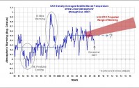
2007 Warmest Year on Record? Coldest in this CenturyBy Lubos Motl, The Reference Frame
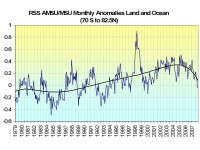
One month ago, we noticed that November 2007 was the coldest month since January 2000. Well, the RSS MSU satellite data prepared by remss.com show that December was even cooler. The December anomaly was -0.046C, compared to -0.014C in November. That means that December 2007 was also cooler than the average December from 1979. Moreover, we can finally complete the ranking of the years!
Let me start with forecasts in the mainstream media. In January 2007, we were informed that 2007 was either likely or certain to surpass 1998 and become the world’s warmest year on record by most media. They justified this statement by referring to scientists who have combined greenhouse gases with the observed El Nino. Many sources, such as the New York Sun, even gave you the probability that 2007 would be the hottest year as 60 percent.
However, the greenhouse gases are not too important and El Nino was replaced by La Nina. As a consequence, RSS MSU data for the lower troposphere show that 2007 was the coldest year in this century so far. In alarmist jargon, it was the ninth hottest year on record: the most recent year was cooler than all other years in this century as well as 1998 (by a whopping 0.41C) and even 1995. Read more here.
The RSS MSU satellite data for the land and ocean between 70S and 82.5N where virtually all the world’s population resides shows a negative departure from normal for the second straight month and the largest since January 2000. The trend which has been flat the last decade has now turned down. Read blog here.
See full size image here
Icecap note: There continues to be differences as Lubos points out between all of the data sources. Roy Spencer’s the UAH AMSU plot of lower tropospheric global temperatures (the most accurate estimates) do not show the downturn or negative anomaly yet but note how the anomaly dropped one half of 1 degree from January to December.
See full size image here
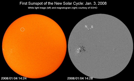
By Anthony Watts, Watts Up With That
What a day! First a major storm whacks the west coast, now we have the official start of solar cycle 24. Solar physicists have been waiting for the appearance of a reversed-polarity sunspot to signal the start of the next solar cycle. The signal for the start of a new cycle is sighting a particular kind of sunspot. That wait is over.
A magnetically reversed, high-latitude sunspot emerged on the surface of the sun today. Just a few months ago, an “All Quiet Alert” had been issued for the sun. This reversed polarity sunspot today marks the beginning of Solar Cycle 24 and the sun’s return back to Solar Maximum. Solar Cycle 24 has been the subject of much speculation due to competing forecasts on whether it will be an highly active or a quiet low cycle. If it is a low cycle, it may very well be a test of validity for some CO2 based AGW theories. Only time will tell. Read more here. Also Anthony notes Russ Steele has some very interesting comments about the length of cycle 23 and a possible return of a Dalton Minimum here.

See full size image here.
By Joseph D’Aleo, CCM
A major blizzard is crossing the Sierras the next two days and promises to leave behind 6 to 10 feet of snow and hurricane force winds in the highest elevations. Check out this official forecast from the Reno NWS forecast office for the highest elevations 7 miles WNW Echo Summit California issued this morning:
Blizzard Warning
Today: Periods of snow. The snow could be heavy at times. Temperature falling to around 19 by 5pm. Strong and damaging winds, with a south wind 85 to 90 mph decreasing to between 75 and 80 mph. Winds could gust as high as 145 mph. Chance of precipitation is 100%. Total daytime snow accumulation of 42 to 48 inches possible.
Tonight: Periods of snow. The snow could be heavy at times. Low around 16. Strong and damaging winds, with a southwest wind 70 to 75 mph decreasing to between 55 and 60 mph. Winds could gust as high as 120 mph. Chance of precipitation is 100%. New snow accumulation of 30 to 36 inches possible.
Saturday: Occasional snow showers. High near 21. Very windy, with a southwest wind between 50 and 55 mph, with gusts as high as 100 mph. Chance of precipitation is 100%. New snow accumulation of 8 to 12 inches possible.
The total snowfall forecast is between 80 and 96 inches of snow.
When a major cold shot and storm occurs in the west, it usually means a big warm-up in the east. Weather across the United States often resembles a see-saw - when it is cold and snowy in the west it is unusually warm in the east while when the east and central is in the midst of a cold wave, they may be playing frisbee and sunning themselves on the beaches in California.
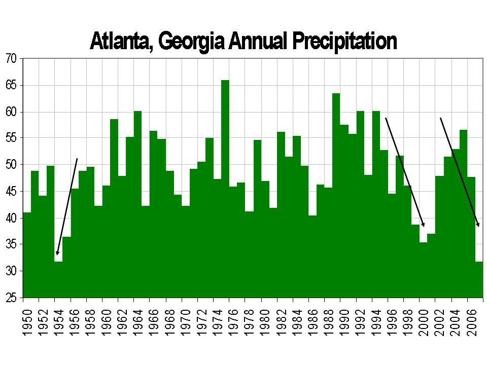
Atlanta Escapes Record Dry Year By a DropBy By Mike Stobbe, AP
This year was almost one for the record books, but then it rained. A lot. After a fourth consecutive day of rain Sunday, 2007 barely missed becoming Atlanta’s driest year on record. That dubious honor goes to 1954, when only 31.80 inches of rain fell.
Atlanta is at the center of a historic drought that has engulfed more than one-third of the Southeast. Sunday’s showers pushed the city up to 31.85 inches for the year. A parade of rainstorms that began the week before Christmas helped Atlanta escape its driest year on record. Rain fell in the city on 10 of the last 12 days. Read more here.
Icecap Note: Extreme drought for the southeast states and other nearby areas have been observed during years in which stronger La Ninas come on during summer on the heels of an El Nino. The prior El Ninos winters are usually dry for the northern Gulf States and the La Nina summer tendency to be hot and dry is further exacerbated by the antecedent (low soil moisture) conditions. 1954 and 1999/2000 are examples of such scenarios and in this case 1954 and 2007 ended in a virtual tie.

Annual Atlanta Precipitation from 1950 to 2007. Larger image here.
By Joseph D’Aleo, CCM
As I write this it is the coldest morning of the winter so far with single digit to sub-zero temperatures across the north from Iowa, Illinois and Missouri east to Pennsylvania, New York and New England. The coldest reading on the map appeared to be -20F in Saranac Lake, NY. The cold extended deep into the south with freezing temperatures to Fort Myers (a record low)and a chilly 39 in Miami and 45 in Key West. Readings were in the high 20s to low 30s across the growing areas, likely doing some damage to vegetables but it appears damage to citrus was minimal. There were even snow flurries in Daytona Beach.
See larger image here
After a frigid day, a moderation will spread from the central states where it begins tomorrow to the east coast this weekend. Temperatures for the early into the middle part of next week will be much above normal in the central and east. There could be some records set. In New York City, it will reach the 60s. Most every day in January has had record highs in the 60s and even 70s (in 1932, 1950 and 2007). Cold will start returning later in the week.
Read more on the causes for the swings and what might lie ahead here.
By John McClaughry, Ethan Allen Institute
On December 4 Vermonters were treated to a well- orchestrated media event designed to terrify them into endorsing a very expensive special interest policy agenda. The occasion was the release of a new report by the Vermont Public Interest Group (VPIRG) claiming that “global warming will substantially increase the odds of extreme precipitation. scientists predict that warming temperatures will increase the frequency of major storm with heavy rainfall or snowfall.”
The report, entitled “When It Rains, It Pours”, was prepared by the Environment America Research and Policy Center created by US PIRG with funding from the Pew Charitable Trust. (Imagine the flip side: how much credibility would you give to a report on climate change produced by the National Coal Association?) The key finding of the report for Vermont is a finding that our state “experienced a 57% increase in extreme rainstorms and snowstorms during the period studied” (1948-2006)
Why did VPIRG choose the period 1948-2006? The report says its conclusions rest on the authority of Dr. David Easterling of the National Climatic Data Center. But the 2003 report cited to Easterling covers the period 1895-2000. In it, incidentally, Easterling observed that “[extreme precipitation] frequencies at the beginning of the 20th century were nearly as high as during the late 20th century for some combinations, suggesting that natural variability cannot be discounted as an important contributor to the recent high values.” Former Lyndon State professor of meteorology Joseph D’Aleo offers this explanation: the first half of the period studied was the beginning of the last cold phase of the Pacific Decadal Oscillation, an ocean current pattern that strongly affects storm tracks and thus precipitation over North America. Half way through the VPIRG study period the PDO flipped to its warm phase. VPIRG carefully picked a period where it could hardly have avoided getting the higher precipitation frequency that it wanted for shock effect. D’Aleo believes that current global warming (and thus warming-related precipitation) is far more influenced by PDO and other ocean current changes than by any contribution produced by human activity.
To their credit, the Vermont news media (Free Press, Vermont Press Bureau, WCAX) sought out some expert opinion. Andy Nash, the National Weather Service lead meteorologist at Burlington, was clearly not buying the VPIRG climate fright. The Free Press reported Nash as observing cautiously that the data could be artifacts of the natural variability of the weather. WCAX quoted Nash as saying that the report does not present new data and raises more questions than it answers. This won’t be the last time that enviro organizations pump up an enviro-scare to promote their political agenda. Vermonters need to greet these continual revelations with a lot of skepticism. Read more here
John McClaughry is President of the Ethan Allen Institute
New Years Day SnowstormBy Jim Irwin, AP
A fast-moving New Year’s Day storm dumped more than a foot of snow on southeastern Michigan, a record blast that made driving hazardous, snarled the flight home for holiday travelers. The storm left 10 to 16 inches of snow across parts of Oakland, Lapeer and St. Clair counties north of Detroit, the National Weather Service said. The western St. Clair County community of Capac reported 16 inches.
“This storm most definitely packed quite a wallop,” said Weather Service meteorologist David Shuler in Oakland County. “This will be a memorable storm for the amount of snow it dumped in such a short amount of time.” He said it was the region’s heaviest New Year’s Day snowstorm on record and was unusual for its intensity. In the heart of the storm, snow fell at a rate of at least 2 inches an hour, with periods of 4 inches an hour. Thousands of people in Michigan and Ohio lost power.
That followed a storm in the Northeast on Monday that made it the snowiest December in the region in decades. December’s snowfall at Concord, N.H., totaled 44.5 inches, toppling a record of 43 inches that had stood since 1876. Burlington, Vt., got 45.7 inches, far above its 17.2-inch December average, and Portland, Maine, amassed 37.7 inches for its third-snowiest December on record. New Hampshire has already spent $30 million on snow removal out of the $75 million budgeted for the entire winter, said highway department spokesman Bill Boynton. However, New England ski resorts enjoyed the flurry of storms after last year’s lack of snow early in the season. In Maine, it provided a fresh layer on top of the roughly 6 feet that the state’s two biggest ski resorts, Sugarloaf USA and Sunday River, each got last month. “It’s been unbelievable,” Sugarloaf spokesman Bill Swain said. “It just keeps coming.”
Read more here.
Icecap Note: Very cold weather (all the way south to Florida) the next few days will give to moderation and in places in the north the best winter sports in a long time this weekend. Next week the warming will be significant through at least midweek. Cold weather will return in stages starting late next week. More on the weeks ahead later this week.
By Steve McIntyre, Climate Audit
The U.S. federal government has a detailed set of regulations requiring scientific information to be peer reviewed before it is disseminated by the federal government. NASA, which says that it has “employs the world’s largest concentration of climate scientists”, has carried out an interesting manuevre that has the effect of evading the federal Data Quality Act, OMB Guidelines and NASA’s own stated policies. Once again, the system involves an employee purporting to be acting in a “personal capacity”.
NASA has several manuals and policies setting out its own procedures for ensuring compliance with such policies. NASA guidelines specify far-reaching obligations on data quality for information disseminated by NASA. The manual contains a header stating: COMPLIANCE IS MANDATORY and does not contain any mechanism whereby a NASA employee can sometimes be a “private citizen” and sometimes be a “NASA employee”, anymore than a company insider can purport to be a “private citizen” in his relationships with a company.
Note: See how NASA’s Gavin Schmidt who also is a prime player at the alarmist Real Climate web site ignored and circumvented these government and NASA guidelines in the NASA Earth Observatory Global Warming Q&A in this Climate Audit blog.
By Clyde E. Stauffer
In the 16th century a large, powerful institution saw itself as threatened by heretics - people who didn’t agree with all its dogmas - so it began to identify and punish those dissidents. Five hundred years later a similar effort is under way. In the 16th century it was the Roman Catholic church; today it is Big Science. The only real difference is that today heretics are simply deprived of their livelihood; burning at the stake is no longer in vogue.
Exhibit One in this contention is found on Page A2 of the Dec. 14 Enquirer: “Global-warning skeptic says he’s being vilified.” This is from an economist, but scientists who express similar doubts about the fashionable view (global warming is due to generation of CO2 by humans) are similarly marginalized. Exhibit Two is the denial of tenure to Guillermo Gonzalez by the astronomy department of Iowa State University, despite a stellar record of scientific publications. His crime? He co-authored a book ("The Privileged Planet") that suggested that the unusually benign (for life) situation of the Earth might have been due to an intelligent designer.
As a doctoral student I was taught that good science sought reliable facts about the world around us, and hypotheses followed wherever those facts lead. Sadly, that no longer seems to be the case. Instead, selected facts have led to politicized conclusions, and countervailing facts are no longer tolerated. This is not good science. Read more here.
Clyde E. Stauffer earned a Ph.D. in biochemistry at the University of Minnesota, has done research at Procter & Gamble, and has been involved in more applied science for the last 30 years.
January Will Start Frigid But the Cold Will Be Followed by Large SwingsBy Joseph D’Aleo, CCM
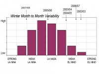
January will start out with some frigid air that will reach all the way down into the deep south. It will make some headlines but will not lock in. An old forecasting empirical rule was a big arctic outbreak is often followed by a big warm-up as the return flow behind the big high pressure pumps warm air north and east just as the northerly flow ahead had driven the cold air well south. It is all a part of the atmosphere bringing about compensation for the large temperature gradients between the polar regions and the tropics. Some record cold mornings will be followed by some warm records especially in places where no snowcover exists. That should last almost a week before the cold returns.
It is rare to have a wall-to-wall cold or warm winter. They start out cold and end warm or start warm and end cold or flip back and forth. La Nina years are especially fickle month-to-month. The weaker the La Nina the more unstable. This is a moderate La Nina.
Full size image here.
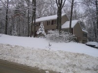
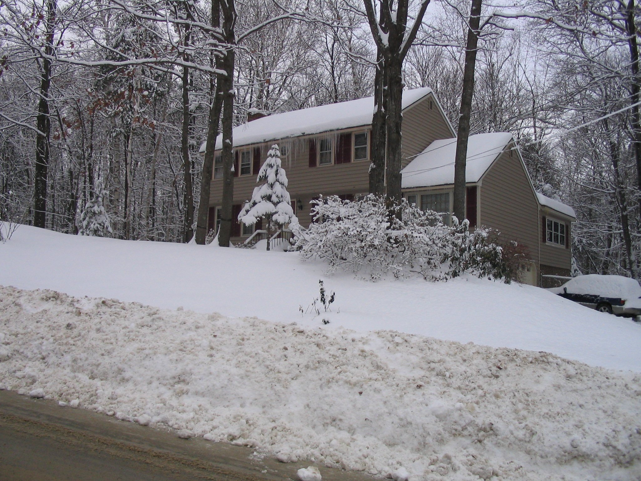
Meanwhile December has been snowy (with hemispheric snowcover above the 10 year average as seen on Dr. Bob Hart’s FSU snow page here). See the snow piles by my home in New Hampshire before last weekend’s rains. My mail box is in there somewhere.
Full size image here.
We will recap some of the record or near record snowfalls and cold December temperatures after the New Year and take a more detailed look ahead then.
By Joseph D’Aleo, CCM
We have shown that using the USHCN climate data for the 1221 climate stations, there has been little (0.21F) in the way of net warming since the last cyclical peak in 1930.
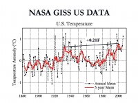
See larger image here
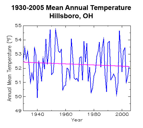
CO2 Science has been doing a weekly plot of these climate stations showing the cyclical nature of the changes and the lack of warming in most stations. This week the station is Hillsboro, Ohio which actually has shown a cooling of 0.30F over the period.

See larger image here
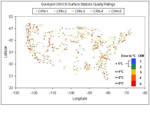
Anthony Watts at surfacestations.org has found poor or very poor siting of the majority of these climate stations (69% at last count) with locations over concrete, volcanic cinders, paved roads or parking lots, location near buildings or air conditioner exhausts, each leading to a warm bias. Thus there is little reason to believe that there has been any real net warming since 1930. Hillsboro is not yet surveyed or rated.
Environmental Policy: More Science and Less Religion PleaseBy Robert Sopuck, Frontier Centre for Public Policy
Environmental policy must be based on the good science and not emotion. In brief:
(1) Environmentalists can be divided into a number of categories ranging from “conservationists” who advocate a policy of “wise use” to the “deep ecologists” who tend to “humanize” nature.
(2) The public at large demands clear and unambiguous statements from environmental scientists while the scientists themselves are dealing with uncertainty and ever-changing information flows.
(3) Science has been described as the “self-correcting process of discovery” which means that what is the received wisdom of today may need to be discarded or modified based on new information.
(4) Policy makers must be aware of the flux inherent in environmental science and ensure that environmental policies must reflect the best science. Read more here.
Robert Sopuck directs the Centre’s Smart Green Frontiers Project which explores how to solve environmental problems without reducing human freedom.